

High and Drying

“This is just one of thousands of small places on the river, already reshaped by a different climate, an echo of a river system that no longer runs naturally. It is a place where creatures belong, but none express rights to its water.” (Journalist Danielle Prokop, in her article Still Pools: Teeming with Life at the Edge [Source NM, Feb. 27, 2023])
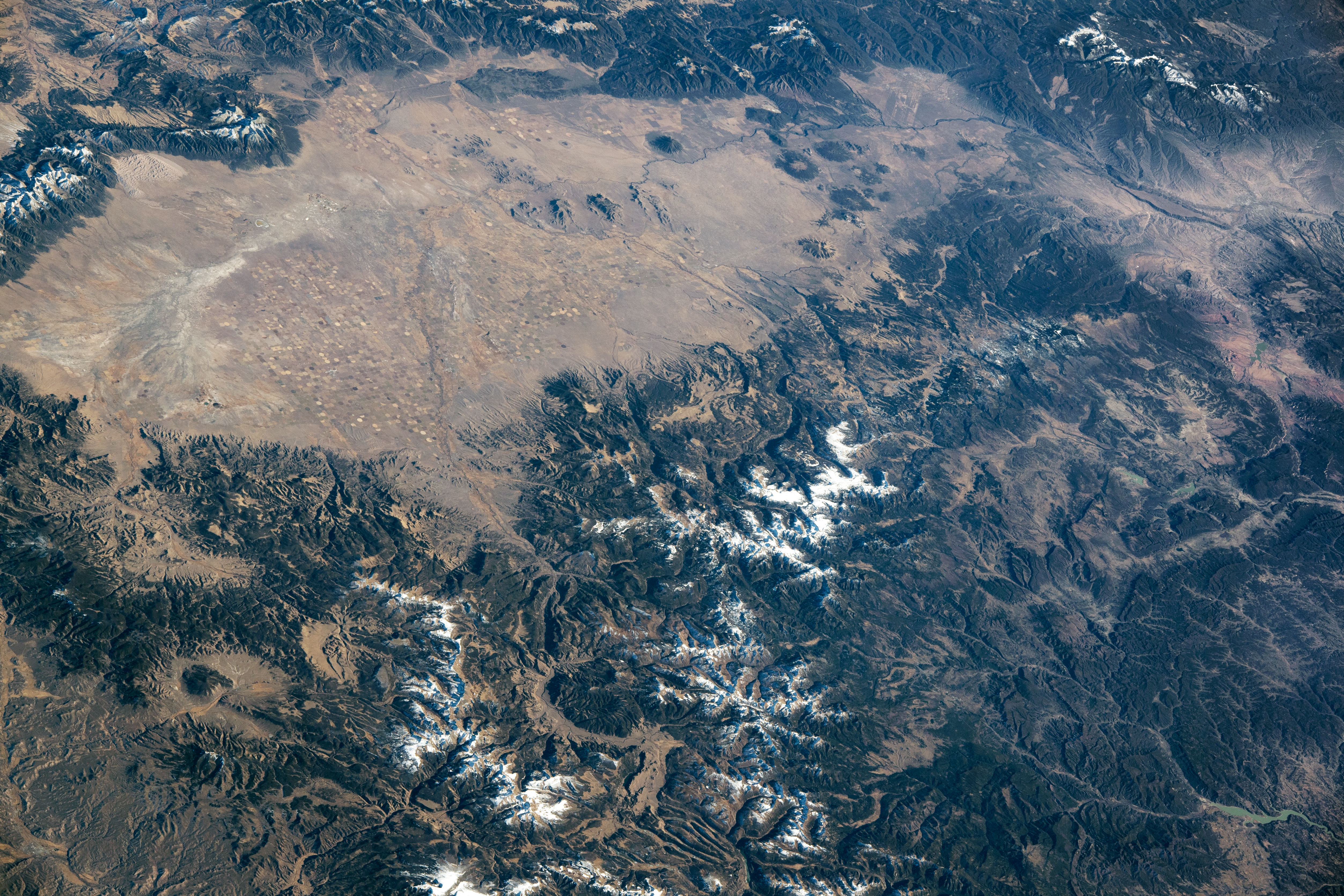
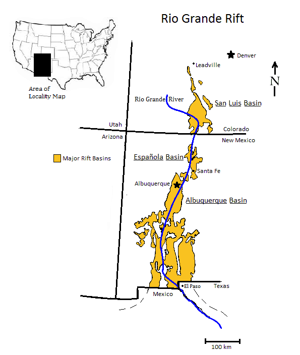
Winding out of the San Juan Mountains, the Rio Grande (visible in the lower part of the image below) crosses a high desert now known as the San Luis Valley, then threads south between volcanic cinder cones (near the top right of image) into the canyons and valleys of New Mexico. The writer I’ve quoted above spent several months last year traveling along the Rio Grande, from its Colorado headwaters into Texas, collecting stories that I highly recommend to anyone wishing to learn more about the river and its challenges. Much of the river’s north to south course follows an ongoing, 30-plus million years long geological oddity called the Rio Grande Rift that stretches from inside Chihuahua, Mexico to Leadville, Colorado — today I’d like to focus on one small place along the river that has an outsized effect on all that happens downstream.
The valley floor is an ancient lake bed that sits above two aquifers. The upper one is an unconfined aquifer fed by groundwater from the Rio Grande and smaller river/creek systems fed by the surrounding mountain ranges. Underneath is a confined aquifer which has, until recent decades, received enough seepage from above to create hydrostatic pressure that fed artesian springs. For most of human history in this valley, use was limited to what the land and available water would support, mostly as seasonal hunting/gathering grounds and as travel corridors. With the arrival of year-around settlements, all that rapidly changed.

Through increasingly organized irrigation and well-drilling systems since the first acequias were excavated in 1851, humans have tapped the underground water bounty, to the point that both aquifers are now the object of warring exploitation and protection schemes. The largest of these, the 85-year-old Rio Grande Compact, is an attempt to guarantee enough flow to continue downstream development of agriculture and urbanization, while maintaining agricultural, urban/rural and (somewhat belatedly) wildlife needs upstream, even as a long-term drought that has become aridification diminishes spring runoffs from the San Juan and Sangre de Cristo Mountain Ranges. Meanwhile, a scheme to pump aquifer water to suburban areas near Denver (while ‘buying and drying’ agricultural water rights in the northern part of the valley) periodically rises from the ashes of previous failed attempts to do the same thing, re-invigorating a valley-wide resistance movement. As you can perhaps imagine, there are lawsuits, congressional interventions and diplomatic negotiations aplenty, with viable long-term agreements not yet in sight.
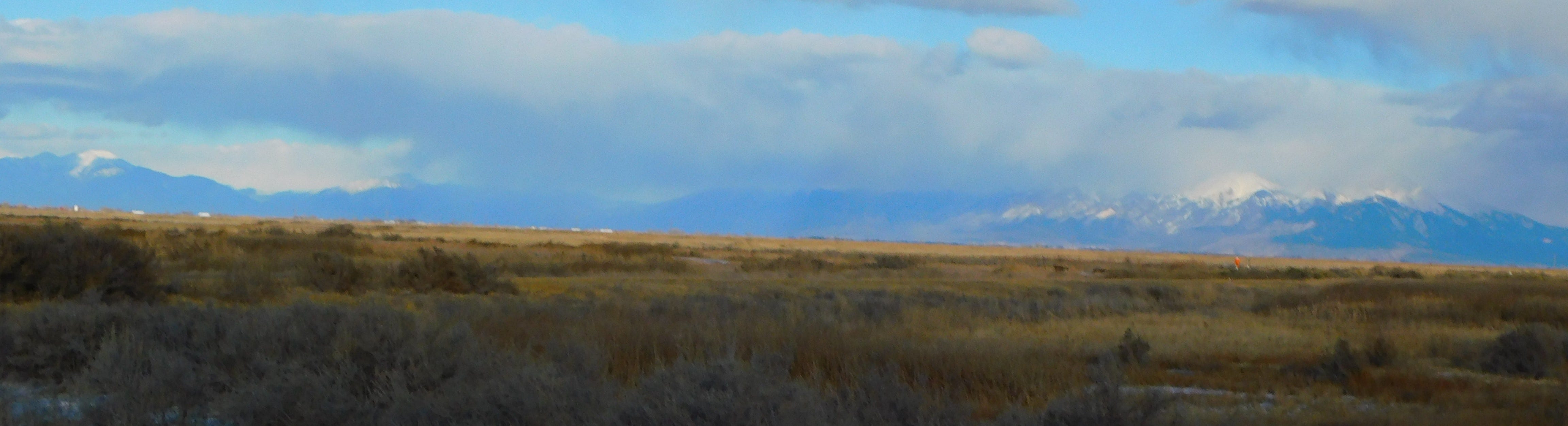
Through all human-occupied periods, other less politically well-connected life forms have depended on the San Luis Valley’s riparian abundance, from the long since extirpated bison to deer and other grazing/browsing species, plus the hundreds of thousands of migrating birds that pass through the valley each spring and autumn, some stopping for up to a month to rest up, regain weight lost on the journey, and shelter from storms sweeping the high mountain ranges ahead. Three National Wildlife Refuges have been established to encourage their survival, with the carrot for humans being a chance to view, and at established times, to hunt the migrants. So far, these efforts have maintained healthy waterfowl migration populations that depend on a combination of natural and artificial ponds for overnight roosting, and on seeds and bugs gleaned from surrounding fields and pastures. All of this depends on allowing the aquifer ecosystems to provide water for in-valley needs, so I’ll steer you back to the work of journalist DanielleProkop, in her profiles of San Luis Valley rancher/farmer Kyler Brown, and of several valley residents working at collaborations that include conserving water and habitat for fish, birds and other species.
This weekend in the San Luis Valley, the 40th edition of the Monte Vista Crane Festival will be happening, so if the bird images of my past few posts have piqued your interest, there will be opportunities to see birds up close, learn from birding aficionados, and (I hope) to appreciate some of the high and dry surrounding habitat for what it is, a unique oasis on top of a geologic anomaly.
Up next, I’ll be taking another look at developments in renewable energy systems, with Distributed and Disabused; until then, take care of yourself and help someone out along your way. - B.
Awhile back I took a wider look at aquifers, in Snowpack to Transpiration, a Physics of Place
Here’s a map of the current snow water equivalent of the snowpack in each of Colorado’s river basins, from the National Weather Service.
For a deep dive into Colorado’s groundwater resources, here’s the Colorado Geological Survey’s Groundwater Atlas.